

First, some family stuff so as to get it out of the way. I’m reading from a letter he wrote to Superintendent L. Parry and Mrs. Bates Wilson, although, he calls them informally Mr. Parry and Robin. The address he’s sending it to is Canyonlands National Park (August 1st, 1984). Here’s the part I want to quote; “In 1935, I began studying and mapping the canyon lands downstream from what later became the Park. From 1935 to 1940 I was engaged in mapping the geology of the Henry Mountains and environs along Glen Canyon. My 1977 paper provides an account of that experience in those pre-Jeep, packhorse days. By then, Alice and I had a son and a daughter, preschool. Alice joined me camping for a month or so each summer, thanks to her parents who took care of the children at their farm in Maine. In 1939 they came west with Alice and began their schooling that fall at Teasdale, Utah. They too became acquainted with the canyon country.”
O.K., that’s good, but it leaves out so much. Their son and daughter, Gene and Ann, were adopted, but adopted in Kentucky I believe. So, Charlie (perhaps for the sake of space) left that out. Family lore has it that a woman dropped off Gene and Ann at an orphanage. Years later, as an adult, Gene was said to have tried to track down his original parents and found that his biological father may have been in prison at the time. (I’m not sure of the veracity). The depression was still going on and a single mother with two little ones and a missing father was in dire straights. There was no welfare. Again, family lore has it that she dropped off the pair at an orphanage out of desperation. Not long after (and I don’t know if it was a day, days, or longer), Charlie and Alice came in to the orphanage. I believe they weren’t able to have children of their own, and wanted to adopt. Like a lot of men, Charlie wanted a son. He saw little blond headed Gene and went to adopt the boy. Gene supposedly screamed in panic something along the lines of “Not without sis! Not without sis!” while pointing at his younger sister. If true, I can totally envision my Aunt Alice saying, “Oh Charlie, we can’t separate the two.” So, they adopted them both. Supposedly, not long after the biological mother came back wanting to have her kids back and thinking she had made a terrible mistake. Gene didn’t want to go back. At that young age, he felt a trust betrayed.
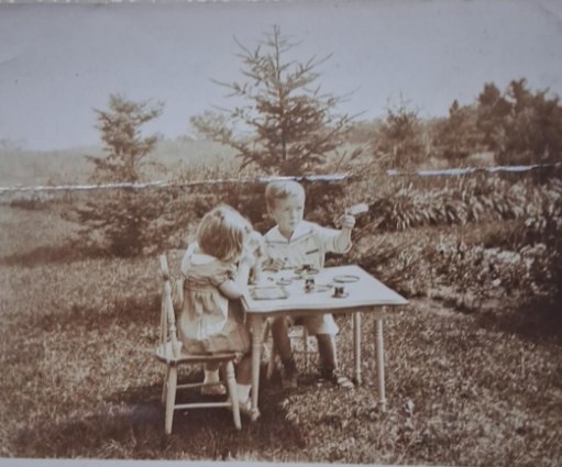
Gene and Ann shortly after being adopted.
O.K., enough with the personal stuff. The year 1939 passed, and according to his biographical sketch, in 1940 and 1941 he was “In charge, manganese investigations by USGS in south-western states. See publications 1942, 1953.” Well, no I won’t Charlie. I can barely make sense of what the technical geology writing is as is. I had to look up what manganese is:
“Manganese is a chemical element; it has the symbol Mn and atomic number 25. It is a hard, brittle, silvery metal, often found in minerals in combination with iron. First isolated in the 1770s, manganese is a transition metal with many industrial alloy uses, particularly in stainless steels in which it improves strength, workability, and resistance to wear. Manganese oxide is used as an oxidising agent, as a rubber additive, and in glass making, fertilizers, and ceramics. Manganese sulfate can be used as a fungicide.
Manganese is also an essential human dietary element, important in macronutrient metabolism, bone formation, and free radical defense systems. It is a critical component in dozens of proteins and enzymes.[8] It is found mostly in the bones, but also the liver, kidneys, and brain.[9] In the human brain, manganese is bound to manganese metalloproteins, most notably glutamine synthetase in astrocytes.”
I guess it’s good to know where that is if your country is on the brink of war and might need some stainless steel. In my previous article, I linked to the article from which I got much of this information. See the article here. Now, to a novice like me, you might think, “What is good is geology during warfare? The movements of glaciers isn’t going to effect the trajectory of bullets. Are we going to be using catapults? No Ivan, don’t use porous rocks in the trebuchet, try digging around for some granite.”
Now, after reading that, you might wonder how come General Patton was such a great geologist. I don’t know that he was, but Patton was part of the Mexican Punitive Expedition otherwise known as the Pancho Villa Expedition. As I recall, President Wilson wanted to declare war on Pancho Villa, and someone asked him, “You want to declare war on one man?” Since that seemed silly, they called it the Mexican Punitive Expedition. (Can’t we call the Iranian war a “Punitive Expedition”. That way, we can declare victory and pull out whenever we want).
As Spaghetti Western enthusiasts may have noticed, parts of Spain resemble the U.S.A.’s southwest. It stands to reason that North Africa’s geography was also similar and Patton recognized that right away.
I will now quote from an unpublished letter that Charlie wrote titled, “History of the Military Geology Unit, During World War II” (1982):
“My background as an Army brat had given me ideas about applications of geology in military operations, and with Bill’s blessing and Fergie’s help, I assembled a sample folio on an area in Morocco. I do not remember the location or the extent of the sample area or the scale of the maps used. The effort simply was to show the kind of information useful to the Corps of Engineers that could be obtained from the splendid collection of topographic and geologic maps in the Survey library. A modified version of that sample folio was later published as USGS Circular 46 (1949). Bill accompanied me in presenting the sample to the Military Intelligence Division OCE. The officers were impressed but skeptical because they could not check their accuracy. We were asked to prepare similar folios about the state of Arizona and one about Madagascar, both of which they could check, the latter because of British operations there. I cannot remember who besides Fergie, Bill and myself helped prepare the Arizona and Madagascar reports but they were prepared, found accurate, and thus began the Military Geology Unit.” (Bill is one Bill Bradley, Fergie is one H.G. Ferguson for what it’s worth).
He continues, “Assignments came every few days, some late in the afternoon that were needed the next morning. When an assignment was received, a team was organized to study the maps and literature to prepare the report. A group of librarians under Marie Siegrist combed the library. Each folio had maps covering the terrain and its effects on movement, cover, and concealment of troops and supplies; possible airfield sites and construction problems there; water supplies; roads and their construction and maintenance problems— all the topics needed for engineering planning plus suitability of the terrain for cross country movement of troops and supplies. Interpretations were presented in tables facing each quadrangle map. Deadlines were set to assure the report was completed in time to be of use. (Editors were needed to minimize bloopers, such as one that slipped through, ‘The valleys are wide and inhabited by Bedouins with date palms in their bottoms’). Ken Lohman managed the units photo lab and was ready to process the completed copy and deliver it, night or day, to the Army Map Service where the folios were published and distributed overseas. The rest of the staff – librarians, scientists, draftsmen, editors, and typists – then would catch up on lost sleep. Many times the staff put in 24 hour days.”
He makes mention that they had to clean out their own office for security reasons. They didn’t trust others to come in and clean it up for them. A visiting Major Arthur Spillers said, “This place looks like a Pennsylvania Railroad train after its run from New York.”
Charlie continues, “The report on eastern Sicily won the unit its spurs. That folio covers fifteen 1/100,000 quadrangles, each accompanied by a table giving details. One set of 15 maps had terrain units (physiographic units) overprinted: Another set had water sources plotted (several thousand). Three 1/200,000 road maps showed possible airfield sites and listed construction problems at them. There were 12 other miscellaneous maps including two physiographic diagrams by Phil King. (Later we learned that such diagrams are more useful to the military if called ‘terrain diagrams’). Finally, there were 39 photographs illustrating the various conditions. In all, 5 lbs of maps and tables on 100 pages.
It was a rush job done in 10 days. A call from the Theater May 9, 1943, requested the study and asked that it be delivered June 1. We split the time with Army Map Service, giving them 10 days to publish the folio and deliver it overseas. This is the kind of rush job that led to the slogan, “In Military Geology, an intelligent quick decision is better than delay in search of the ideal.” Graffiti in the dungeon shortened this to “Don’t think – Act.” During the war the unit delivered 140 folios, most of them like the one on east Sicily – about one week.
After Sicily was secured, General Davidson, Chief Engineer for the operation, cabled how useful the maps had been. “In many cases they had more information than the natives themselves”. Needless to say, those who worked so much overtime were justifiably proud of their accomplishment. So many requests immediately followed the unit had to double to about 50 persons, and later doubled again to more than 100.
As already noted, the British Military Geology Unit carried responsibility for terrain information about Normandy and the rest of western Europe. There also was coordination of effort in Washington. The Navy Hydrographic office provided information about anchorages. The Beach Erosion Board provided information about landing areas, from the anchorages into and onto the beaches. The Military Geology Unit provided information about the terrain inland from the beaches.
During stage 3 the Unit directed its attention chiefly to the Pacific, and there began a new activity, participation by geologists in the Theater of Operations. At Leyte, three from the United landed on D day plus 1. They did their field geology under enemy fire.”
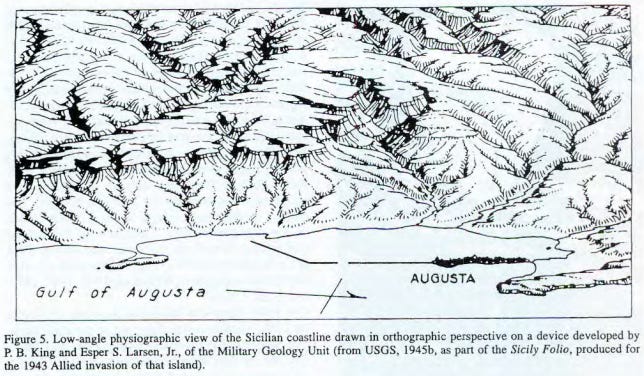
(In one of the articles, Charlie makes mention that most military officers could not read a topographical map, so, it was easier to give them a diagram like the one above so the officers knew with what they were dealing).
He then makes mention of the Japanese attempt to set the west coast of the United States and Canada on fire by using balloons. Charlie makes mention that story has been covered elsewhere. In one of Charlie’s files, he had a The New Yorker article on it. I found it here. Unlike in the print copy, the online copy starts off with an unrelated story having to do with forensic geology in solving crimes. You have to scroll way down till you see the start of a paragraph with “Japan in 1944.”

20 year veteran of the U.S. Border Patrol. Author of "What Bridge Do You Work At? Or, Kids Are Cute; Therefore, Open Borders" & "East into the Sunset: Memories of patrolling in the Rio Grande Valley at the turn of the century". Books are available at Amazon, Barnes and Noble, as well as Thrift Books.
Master's Degree in Justice, Law and Society from American University.
Grew up partly in Europe.


")
")
")


")